Geometric Design of Roads
Geometric Design of Highways and Roadways
Starting out, it’s best to define some terms that the readers might find confusing. The terms are “road” and “roads and highways.” Roads and highways can be defined as land that has been cleared and improved so that people can move from one place to another and deliver goods from place to place. Road on the other hand has wider application to it and usually refers to the public’s transportation systems. Its usage is not limited to roads and highways as it can also refer to railways.
Geometric design of roads, or as it is simply known, geometric design, is a type of study in road engineering that deals with the geometrical features of the roadway. AASHTO has established guidelines for geometric design of roads applicable to rural and urban roads. Local roads can be defined as a road whose main function is to provide access to residences, businesses, and property owners.
Local rural roads consists of a two-lane local roads and the general design considerations for this type of road are shown below and are based on AASHTO guidelines 2001:
Design Speed
Design speed, according to AASHTO, is the speed that is selected to determine the conceptual design of the roadway that will have a major influence on traffic operations. AASHTO states that the design speed should be set as maximum as possible so that drivers are satisfied with the level of services of the road throughout its life span.
The design speed for flat terrain is 45 km/hr for 0 – 250 vehicles per day, 60 km/hr for 250 – 400 vehicles per day, and 75 km/hr for vehicles ranging from 400 and above. Design speed for rolling terrain is 30 km/hr for 0 -50 vehicles per day, 45 km/hr for 50 – 400 vehicles per day, and 60 km/hr for the amount of vehicles ranging from 400 and above. Mountainous terrain’s design speed is 30 km/hr for daily traffic ranging from 0 – 400 vehicles per day and 45 km/hr for traffic ranging from 400 vehicles per day and above.
Low volume traffic ranging from 0 to 50 vehicles per day with design speed for flat terrain is 45 km/hour, rolling terrain with 30 km/hour, and mountainous terrain is 30 km/hour. It can be concluded that the design speed of vehicles is influenced by the average daily traffic and types of terrain.
Alignment
When a design engineer designs a road system, he/she should not design the roadway with a sudden change from flat to sharp curve. This not only causes discomfort for drivers, but also will invite accidents. This is where road alignment comes into use. Alignment of a road is composed of horizontal and vertical alignment.
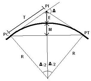
The intersection of a road must be provided with certain degree of curve which is determined by its radius, so that when a vehicle is moving towards the corner of a road, the driver of the vehicle will not feel any sudden changes while driving and will have a comfortable driving experience. This curve is known as horizontal alignment and usually provided on a horizontal profile of a road, which is simply known as the plan view. The road curve is provided based on its relation with design speed, which can be shown by the formula below.
where R = the radius of curve (ft)
V = the vehicle speed (mph)
e = the rate of roadway superelevation (in percent)
f = the side friction (demand) factor
Image source = wikipedia/AdamD
Vertical alignment is a curve provided by the designers during the design phase on the vertical profile of a roadway. These curves consist of crest vertical curve and sag vertical curve. The main objective of vertical alignment is to give a gradual change of a road slope when a vehicle is moving uphill or downhill.
Grades
AASHTO has set maximum grades based on the types of roads and design speeds. For low-volume local rural roads, grades may be 2% steeper. Roads with design speed of 70 miles per hour have maximum grades of about 5 % and a 30 miles per hour design speed; AASHTO has set the maximum grades range from 7 to 12 %.
Width of Roadway
The design speed of vehicles will influence the width of the road and when the design speed increases, the width of roadway also increases proportionally.
Sight Distance
The ability of a driver to see the road ahead is called sight distance. It is the most important to the safety and smoothness of traffic operations of a road. The road design engineer who is in charge of the design process must provide sufficient sight distance of a certain length. Sufficient sight distance is crucial in road design so that drivers can control their speed while driving and to avoid striking unexpected vehicles coming from the opposite direction of travel. Roadways with two lanes must have sufficient sight distance to enable drivers to overtake another vehicle safely without striking any vehicle traveling in the opposite direction.
Superelevation
When a vehicle is navigating from a normal straight road to a curve, the elevation of the left edge of the road will gradually get higher than the right edge of the road or vice versa depending on the topography of the road. This is also known as superelevation or road cambering, and its main purpose is to counter balance the centrifugal force of the vehicle navigating on road corners.
Conclusion
It is safe to say that AASHTO’s guidelines on geometric design are crucial to transportation engineering because they emphasize the safety of the driver, providing maximum efficiency of traffic operations and comfort to road users. Each of the design consideration above is promoting the safety of the driver but even so, more research should be conducted in the future so that these guidelines can be improved and so that good design can produce increased traffic safety as ever more users come to our streets and highways.
References
- A POLICY on GEOMETRIC DESIGN of HIGHWAYS and STREETS 2001 Fourth Edition By: American Association of State Highway And Transportation Officials
- Highway Engineering Handbook, 3ed By: Roger L. Brockenbrough (Author)
- Wikipedia / Geometric design of roads