What are Geodetic Measuring Devices? Total Stations, Dumpy Levels, Global Navigation Satellite System Receivers

Introduction
Geodetic measuring procedures are used to quantify georeferenced points or motions in one, two, or three dimensions. This is done with the help of tools like total stations, levels, and global navigation satellite system receivers.
Total Stations
A total station is an electronic/optical tool utilized in modern surveying. A total station is used for carrying out goniometric measurements concurrently with measurement of lengths. The device is used for civil work as well as to solve other problems, and renders savings in terms of the work force required and the time taken for decision making. The total station is an irreplaceable device because it helps in transferring the data calculated during measurements. This is carried out through a special interface with a computer.
The basic attributes of a total station are unrivaled range, speed, and correctness of measurements. The instrument is designed to measure slant distances, straight and perpendicular angles, and altitudes in topographical and geodesic works, tachometric surveys, and to solve applications of geodetic tasks. Angles and distances are evaluated to degrees under survey, and the coordinates (X, Y, Z or north, east and elevation) of reviewed points proportional to the total station perspective are computed using trigonometry and triangulation. Some total stations comprise an interface with the global navigation satellite system, and this helps in combining the advantages of these two engineering disciplines and lessen the issues of each technology’s limits.
Dumpy Levels
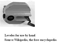
A dumpy level is an optical instrument which is used in surveying and building to relocate, calculate, or set horizontal levels. It is set up on a tripod and, reckoning on the type, either approximately or accurately is set to a level condition with the help of foot screws. A telescope is attached to one side of the instrument’s axis of rotation.The operator uses the eyepiece of the telescope, and his helper applies a tape measure or fine-tuned staff erect at the level under measurement. The instrument is used to collect and transfer elevations while carrying out site surveys or building construction. Measurement normally begins from a standard with recognized height fixed by a preceding survey, or a random point with an unspecified height.
A dumpy level is a previous-style instrument that calls for competent use to set precisely. The instrument has to be set level in each quarter-circle, to make sure it is correct through a entire 360° range. (A refinement of the dumpy level allowed it be tossed through 180° with its head fixed.)
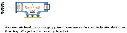
An automatic level has an internal compensator mechanism which aids in automatic removal of any residual variation when it is set close to level. These instruments are the favored instrument on building sites, erection, and surveying because of the speed and ease with which it can be setup.
Global Navigation Satellite Systems
Global Navigation Satellite Systems (GNSS) is the typical general term for satellite navigation systems. These systems provide independent geo-spatial placing with global coverage. GNSS permits small electronic recipients to establish their longitude, latitude, and altitude. This is achieved within a few meters with the use of time signals carried down a line-of-sight by data links from satellites.